E1 - Monteneubel Circular Route Enkirch
- start: Tourist Info Enkirch
- destination: Tourist Info Enkirch
- medium
- 5,70 km
- 1 hour 41 minutes
- 220 m
- 268 m
- 99 m
- 60 / 100
- 40 / 100
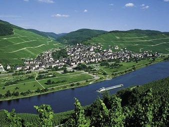
Circular route through the Enkirch vineyards Edelberg and Monteneubel with impressive viewpoints over Enkirch and the Moselle valley.
This leisurely route offers many different landscapes, from vineyards to forest and meadows. At the end, you are rewarded with a magnificent view from Enkircher Steffensberg.
General information
Directions
The starting point of this route is the fountain square in front of the Tourist Info Enkirch. Following the intersection along the street "Am Steffensberg", the path turns left at the first street, "Im Bungert". Via the streets "Im Bungert" and "Am Edelberg" you reach the vineyard "Enkircher Edelberg". Following the "E1" signposting, you reach the forest edge, high above the vineyards of the "Enkircher Monteneubel", a vineyard already mentioned around 1200 and thus one of the oldest named vineyards in Enkirch. After circling the sports field, the path leads downhill along the Monteneubelbach. A short detour via the viewing pavilion on a hill of the vineyard "Enkircher Steffensberg" leads the way back to the starting point.
Equipment
Easily walkable with light hiking shoes
Tip
The best seasons are during the flowering and harvest of the vines. Watch the winemakers at work.
A detour to the five-valley viewpoint is worthwhile.
Getting there
By car via federal highway B53, L192 or L193 to Enkirch on the Moselle. Parking at the Moselle parking lot Enkirch. About 150 m to the starting point.
Parking
Parking at the Moselle parking lot Enkirch - free of charge. About 150 m to the starting point
Public transit
By train (Easter to October): with the Mosel Wine Train to the Kövenig stop, then by ferry to Enkirch. About 150 m from the ferry to the starting point.
By bus with line 333 (Moselbahn, Trier-Bullay) or line 720 (Bullay-Traben-Trabach) to the Enkirch stop. About 150 m to the starting point.
Literature
"Enkirch - Info" or "Panorama hiking map" Enkirch
Both available at the Tourist Info
Maps
Topographic hiking map 1:25,000
Hiking area Moselle region Traben-Trarbach Kröv
ISBN: 978-3-944-620-24-4
Additional Information
Weather

This tour is presented by: Moselregion Traben-Trarbach Kröv, Author: Birgit Immich


