Moselsteig detour Moseltalschanzen
- start: Parking lot at the Moselle riverbank, district Trarbach
- destination: Parking lot at the Moselle riverbank, district Trarbach
- difficult
- 16,23 km
- 6 hours
- 670 m
- 430 m
- 100 m
- 60 / 100
- 100 / 100
Of elves, hot springs, and relaxing thermal baths.
The Moselsteig detour Moseltalschanzen connects the two towns Traben-Trarbach and Bernkastel-Kues and numerous nature and cultural highlights. Stunning views, natural paths, side valleys of the Moselle, the Jugendstil town Traben-Trarbach, the half-timbered backdrop in Bernkastel-Kues, and the eponymous "Graacher Schanzen" await you on this route. It displays the full diversity of the Moselle landscape over 17 km.
It starts with the Kautenbach valley deeply cut into the slate, where on its varied paths you master the strenuous ascent to the height briefly. The paths on the height offer the chance to catch your breath. The views into the Moselle valley along the ridge are spectacular, and numerous rest options for a break are available. The Graacher Schanzen offer the possibility to explore a part of the region's history. The return descent to Traben-Trarbach shows the diversity of a Moselle side valley: forest, meadows, fruit, and of course vineyards.
General information
Directions
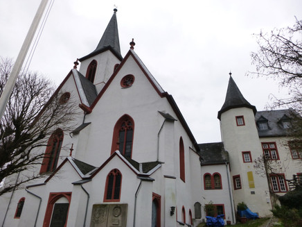
The detour starts from the parking lot at the Moselle riverbank through the underpass of the B 53 into the district of Trarbach. Along Moselstraße, you pass the Middle Moselle Museum and the town hall heading towards the Protestant church. At the town hall, the path turns into Kirchgasse. Via a steep staircase, you reach the forecourt of the church, which offers a beautiful view of the district of the twin town located on the right Moselle riverbank.
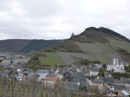
The path continues through an archway of the remaining city fortifications. A steep, paved path leads you past the cemetery into the vineyards. Slightly less steep, the trail continues on the hillside path into the valley of the Kautenbach, characterized by many former vineyards. Before descending in switchbacks, you should take a look over the edge of the slope. Here you have a good view from Ungsberg to the Moseltherme, where swimming in thermal water outdoors is possible even in winter. The upstream view centers on the rock formation Bischofsmütze, which is the next intermediate target of the Moselsteig detour.
Now you descend steeply into the Kautenbach valley along old vineyard paths between vines and slate walls. After crossing the road, the path ascends to the entrance area of the thermal bath. The next section leads you along the Elfenweg into the Trarbacher Schweiz, one of 8 'Switzerlands' along the Moselle. The trails and paths wind steadily up and down along the rocky hillside. After a side valley with the Rote Quelle, the path descends until shortly before Wildstein. Now begins the partly steep ascent to the Bischofsmütze. The effort is rewarded by the magnificent paths lined with moss cushions.
The Bischofsmütze rock formation is composed of quartz and offers a beautiful view into the Kautenbach valley. A nice spot for a rest. The ascent is not yet fully completed as it continues uphill to the shelter at the old Wildstein sports ground. The ensuing forest roads grant you a wide view over the Kautenbach valley into the Hunsrück. At the forest edge, the view towards the south to the town of Longkamp on the plateau opens up. In the high forest, the path only climbs gently until it reaches the new B 50 track. After passing underneath the road, the detour runs a short stretch along the track. Together with the Bärensteig detour, the path enters the forest and leads steeply downhill into the Kallenfels valley. The descent ends at a bridge over the stream, where the detour meets the Moselsteig. From here it is possible to descend via the Moselsteig to Bernkastel-Kues. Continuing on the detour and Moselsteig, you head steeply uphill through the oak-covered slope to the next destination, Maria Zill. Up to the Horstenkreuz junction, it gets steep again. Now it's not far uphill anymore. The Maria Zill viewpoint makes up for the effort with a great panorama from Bernkastel over Wehlen to Zeltingen-Rachtig and Machern Monastery.
You can also take a break 200 meters further at the Maria Zill shelter; the edge of the slope here also offers a magnificent panoramic view.
The detour and Moselsteig lead you down a path into the Kaisergarten. You cross a damp valley bottom using stepping stones and reach the hiking parking lot at the Graacher Schäferei, which can also be used as a starting point for the detour. Here detour and Moselsteig separate.
The ascent to the Graacher Schanzen leads partly along the road to the Traver Kupp viewpoint. The view here is just as impressive as at Maria Zill. The following path leads you steeply uphill through the forest. Over a green bridge, you cross the B50 new road again. The Graacher Schanzen, the namesake of the path, are reached. This defensive structure was built at the end of the 18th century. Here, the Prussian army entrenched itself against the French revolutionary armies. The system of ditches and ramparts is still clearly visible today. The path mostly follows a rampart. This is the highest point of the Moselsteig detour at 434 m.
At the forest edge, you can take a rest with a great panoramic view over the Moselle valley reaching far into the Eifel. Over meadows begins the descent towards Traben-Trarbach. Further in the forest, you descend a rocky ridge until you reach the road. The detour crosses the Camper Bächelchen. The path leads steadily downhill into the vineyards. The steep rows of vines belong to the vineyard site Trarbacher Hühnerberg, which was already known around the turn of the 19th to 20th century. The steep slope is amphitheater-shaped facing southeast and thus exposed to high solar radiation. Further down, you reach the vineyard site "Taubenhaus" with a nice rest area.
The end of the Moselsteig detour is a narrow cobblestone path that leads into the street "Wolfer Weg." The starting point at the Moselle riverbank is now only a few steps away.
Equipment
Sturdy footwear recommended.
Tip
The Moselsteig detour Moseltalschanzen connects the towns of Traben-Trarbach and Bernkastel-Kues. The start is possible in both places. If you don’t want to hike the entire route (one-way about 8 km), you can return by ship or bus from Bernkastel-Kues or Traben-Trarbach to your respective starting point.
After the hike, you should visit the gastronomy or a winemaker in Bernkastel-Kues or Traben-Trarbach. For relaxing, the one in Traben-Trarbach is especially suitable.
On the way, the tavern "Waldschenke mit Herz" (formerly "Zur eisernen Weinkarte") is worth a detour.
Getting there
Traben-Trarbach, district Trarbach and Bernkastel-Kues: B 53 between Zell (Moselle) and Bernkastel-Kues
Parking
In Traben-Trarbach and Bernkastel-Kues: parking lot at the Moselle riverbank
Public transit
The train station in the Traben district of the Moselbahn (RB 85 hourly from Bullay) is located on the other side of the Moselle. Via the marked Moselsteig access path, you reach the start of the Moselsteig detour after approx. 1 km.
Literature
"Seitensprünge Band 2" - 17 premium circular hikes from Bernkastel-Kues to Koblenz by ideemedia
Authors: Ulrike Poller, Wolfgang Todt, Publisher: ideemedia, 160 pages, format: 11.0 x 16.4 cm, ISBN: 978-3-942779-60-9, €12.95
Maps
Moselle hiking map - Ferienland Bernkastel-Kues, 1:25,000, 1st edition 2016, ISBN 978-3-944620-05-3
Additional Information
Mosellandtouristik GmbH
Kordelweg 1, 54470 Bernkastel-Kues; phone: 06531/97330
Tourist Information Traben-Trarbach
Am Bahnhof 5, 56841 Traben-Trarbach; phone: 06541/83980
Mosel Guest Center (Tourist Information)
Gestade 6, 54470 Bernkastel-Kues; phone: 06531/500190
Pavings
- Asphalt Coating (8%)
- Hiking Trail (55%)
- Path (29%)
- Crushed Rock (4%)
- Street (1%)
- Unknown (3%)
Weather

This tour is presented by: Mosel. Faszination Urlaub, Author: Mosellandtouristik GmbH


