Moselsteig stage 13: Traben-Trarbach – Reil
- start: Traben-Trarbach: Traben district, crossroads Poststraße/Am Bahnhof
- destination: Reil: Station on Kaiserstraße
- medium
- 15,22 km
- 5 hours
- 435 m
- 375 m
- 95 m
- 80 / 100
- 60 / 100
This stage offers deep insights and wide views.
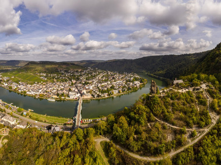
Right after the start in Traben-Trarbach, the Moselsteig delights with unusually appealing perspectives: Over steep serpentine paths, the trail leads directly to the romantic ruin of Grevenburg and there offers a view of the renowned Art Nouveau town. After gaining some more altitude, the hiker can again look forward to viewpoints and unforgettable views of the Moselle valley. The authentic Moselle romance is then shown by the wine village of Enkirch with its many half-timbered houses. From there, the route leads downstream along the Moselle through vineyards to Reil, where you can relax your day in rustic cellars and old vineyards.
General information
Directions
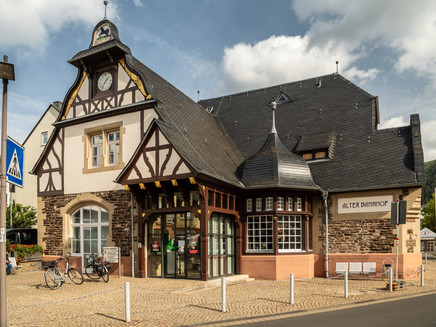
The stage starts in Traben on Poststraße. If you arrive by train, you can reach this place via the marked access path. First, cross the bridge to the other side of the Moselle. On this Hunsrück side lies the Trarbach district. An access path leads from the bridge tavern to the large car park on the Moselle. Following a serpentine path, you now climb the steep forest slope. After countless hairpin bends, you reach the ruin of Grevenburg, which is also operated in summer. From here, you get your first view of the double town lying in the valley. Discover Grevenburg in its original appearance. Download the free ARGO app for this purpose and use an augmented reality application via your smartphone or tablet that shows you the original building as if it were still standing unchanged in its place. The free app and further information about Grevenburg can be found at www.ar-route.eu.
After a section on the castle access road, the path follows a steep, narrow slate path. The view at the “Himmelspforte” is worth a short stop or even a longer rest; the bench here invites you to linger. The ascent is not yet completely done, but the incline on the forest path to Bismarckhöhe is a child's play compared to what you have already mastered. At the height, the view invites you to a longer break: You overlook the entire Traben-Trarbach river bend and in the middle of the loop the plateau with the ruins of Mont Royal fortress and the small airfield area.
From the viewpoint, the Moselsteig then leads over a path through the forest. After some stairs, the lowest point is reached for now. Shortly afterwards, the path rises again on a path. The slope gets steeper and the narrow path clings closely to it. You now walk on a dreamlike section through the forest dominated by low oaks. A short spur leads to the viewpoint Auf'm Rech, which offers a shelter, a rest area, and a fascinating view of the Moselle landscape. The Moselsteig continues a bit further on the path through the slope and reaches the former school playground of Starkenburg. Here you should definitely enjoy the view for a moment! You can also discover the medieval Starkenburg castle ruin in its original appearance via the ARGO app. The app and further information about the castle ruin can again be found at www.ar-route.eu.
Up the stairs, it goes to the main street of the small village, which lies like an eagle's nest on the ridge between Moselle and Ahringsbach valley. The path changes the mountain side and leads through the slope, which descends very steeply to the Ahringsbach.
After crossing a street, the mountain ridge is soon reached again. The Moselsteig changes again to the Moselle-facing slope, and now begins a path that impresses with rugged slate rocks and great views of the Moselle: For the next 1.5 km, the Moselsteig follows very closely along the ridge, which partly leads as a narrow, free rock ridge parallel to the Moselle valley – a path with rocky ground, back and forth, up and down, and changing views, a really dreamlike section! Several huts and benches are well distributed along the way. The Kirster ridge then ends at the Rottenblick rest area, from which you can already see the next intermediate destination Enkirch.
Now the path goes downhill into Enkirch. After a short section through the narrow alleys, you reach a path that brings you further down from the upper to the lower village. At the bottom, you cross the Großbach on a footbridge. At the Brunnenplatz, you reach the center of Enkirch. Through a side street, you reach the edge of the village again. After crossing a small side valley, the path leads through vineyards. Between the rows of vines, it first goes steeply uphill before a slope-parallel path reaches the forest. The path now remains approximately at one height. Via an access path loop, you can visit the wine-growing community of Burg. Through the vineyards, you reach a chapel. Here, the Moselsteig meets a wine teaching path, which you follow to the next rest opportunity. From here, too, an access path leads to Burg. The path now runs mostly through fallow areas of former vineyards, which does not detract from the hiking experience, because the view of the Moselle valley is all the better! The “comfortable” section on the meadow path ends quite suddenly at a crossing. On a path, the Moselsteig crosses a fallow area and reaches a lower slope path. A short section on this vineyard path with a beautiful view of the stage destination Reil follows, then the steep descent awaits you. (At this point, there is also an access path to Pünderich.) Quickly, the Reil bridge is reached over the steep vineyard path, over which you change the Moselle side for the second time on this day's stage. Along Kaiserstraße, you come to the station, the end point of the stage.
Equipment
- sturdy footwear
- weather-appropriate, practical hiking clothing
- rucksack provisions
Tip
The stage can also be well divided into two sections, as there is a bus stop for the Zell – Traben-Trarbach line in Enkirch just 200 m from the main path (marked access path). The sections are then 8 km (to Traben-Trarbach) and 7 km (to Reil) long. The stops in Traben-Trarbach and Reil are located on the Hunsrück side at the B 53.
Video tip:
Hiking check by Landesschau Rheinland-Pfalz - The 13th stage of the Moselsteig
Getting there
Starting point: Traben-Trarbach, B 53 between Bernkastel-Kues and Zell
End point: Reil, junction B 53 between Traben-Trarbach and Zell via the bridge, junction from B 49 between Wittlich and Cochem via L 105 to Reil
Parking
Traben-Trarbach: Parking on both sides of the Moselle (partially paid)
Reil: There is limited parking at the station, sufficient parking on the Moselle riverbank.
Public transit
You can reach the stage towns Traben-Trarbach (station stop) and Reil (station stop) by train (RB 82) or bus line 720 (at Reil stop B 53).
There are regular connections. Please note that during the school holidays of Rhineland-Palatinate / Saarland, on weekends, and on public holidays, there may be restrictions on the frequency! Please take the current daily departure times from the timetable information on the website of the Verkehrsverbund Region Trier (VRT):
Literature
"Moselsteig" - Official Moselsteig hiking guide by ideemedia, €14.95
Authors: Ulrike Poller, Wolfgang Todt, Publisher: ideemedia, 300 pages with almost 300 pictures, elevation profiles, QR codes and GPS tracks, format 11.5 x 23 cm, ISBN: 978-3-942779-21-0, €14.95
"Official Moselsteig hiking maps" in pocket format:
The entire route is divided into 3 maps:
Leisure map Moselsteig - map 1: Perl - Trier (stages 1 - 4), ISBN: 978-3-89637-419-6
Leisure map Moselsteig - map 2: Trier - Zell (Moselle) (stages 5 - 14), ISBN: 978-3-89637-420-2
Leisure map Moselsteig - map 3: Zell (Moselle) - Koblenz (stages 15 - 24), ISBN: 978-3-89637-421-9
Single map: €5.90
Maps in 3-set: €14.50 (ISBN: 978-3-89637422-6)
"Premium set"
Premium set, consisting of official hiking guide including 3-map set, publisher: ideemedia, ISBN: 978-3-942779-24-1, €26.95
The hiking guides and maps are available in bookstores or on the website https://www.visitmosel.de/wandern/service-infos-tipps under the section "Prospect order".
Maps
Leisure map Moselsteig - map 2: Trier - Zell (Moselle) (stages 5 - 14), ISBN: 978-3-89637-420-2
Additional Information
Mosellandtouristik GmbH
Kordelweg 1, 54470 Bernkastel-Kues; phone: +49 (0)6531/97330
Tourist information Traben-Trarbach
Am Bahnhof 5, 56841 Traben-Trarbach; phone: +49 (0)6541/83980
Tourism association Moselle region Traben-Trarbach Kröv
Bahnstraße 22, 56841 Traben-Trarbach; phone: +49 (0)6541/8184572
Weather

This tour is presented by: Mosel. Faszination Urlaub, Author: Mosellandtouristik GmbH


