T 6 - From Traben-Trarbach via the "Iron Wine Map" to Kautenbach
- start: riverbanks Trarbach
- destination: riverbanks Trarbach
- medium
- 15,05 km
- 5 hours
- 454 m
- 435 m
- 102 m
- 80 / 100
- 40 / 100
This hike starts with a climb of about 3 km and compensates with beautiful, comfortable paths further on.
Beautiful panoramic views of the Hunsrück and the Mostel valley await the hiker here. Especially in spring and summer, many interesting plants can also be admired.
General information
Directions
From the car park on the banks of the Moselle in Trarbach, we walk through the subway and follow Moselstraße and Weiherstraße (via the market square) to Weihertorplatz. There we turn right into Wildbadstraße and after about 200 mtr. (directly behind the fountain) turn right into Bernkasteler Weg.
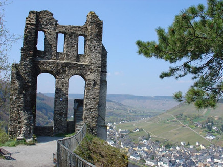
Go straight on between the Gymnasium and the former Alumnat (be careful not to follow the T8). Behind the grammar school, we turn right and walk uphill through orchards, disused vineyards and woodland, always climbing slightly. After a few hundred metres, you come to a high dry stone wall. Keep sharp left here and follow the road. Soon we are rewarded with a beautiful view of the town and the ruins of Grevenburg Castle. The path continues slightly upwards through sparse forest and we soon reach meadows and pastures. Now go straight on for a short distance to the asphalted road - on the right you will see the historic and new iron wine map.
The T 6 continues on the left on asphalt road (after 400 m detour to the Maria Zill viewpoint with panoramic view of Bernkastel possible approx. 2 km). This is the highest point of the hike at 436 metres above sea level.
After about 2.5 km, the path leads to a trail spider in the forest. Here we take the 2nd path on the left and follow the path with a wonderful view of Longkamp. A few metres beyond this great view, we turn left into the forest path. This leads ever so slightly downhill and crosses a road. Directly opposite, our hiking trail continues past the former Kautenbach sports field and turns right onto the paved path. After 1 km, take another sharp left on the paved road to the village of Kautenbach. Turn left down Wildbadstraße to the last house on the right, cross the Kautenbach and follow the T2 signs to the starting point at the Moselufer Trarbach.
Equipment
The trail is good to walk in comfortable shoes. In rainy weather it is better to wear sturdy walking shoes, as the ground can be muddy in some places.
Tip
At the old Kautenbach sports ground, it is worth taking a detour around the old Celtic settlement.
Getting there
Coming by car to the Trarbach district
Parking
free parking at the riverbanks Trarbach
Public transit
Moselbahn bus line 333 or by train to Traben station. From there, cross the bridge and walk along Brückenstraße to the start of the tour.
Maps
Topographic Hiking Map 1:25.000
Moselregion Traben-Trarbach Kröv
ISBN: 978-3-944-620-24-4
Additional Information
Tourist-Information Traben-Trarbach
Am Bahnhof 5
56841 Traben-Trarbach
06541-83980
www.traben-trarbach.de
info@traben-trarbach.de
Pavings
- Asphalt Coating (6%)
- Street (13%)
- Path (18%)
- Crushed Rock (22%)
- Hiking Trail (39%)
- Unknown (3%)
Weather

This tour is presented by: Moselregion Traben-Trarbach Kröv, Author: Wiebke Pfitzmann


