Side trail Leiermannspfad
- start: Enkirch
- destination: Starkenburg
- medium
- 11,08 km
- 3 hours 20 minutes
- 279 m
- 373 m
- 114 m
- 80 / 100
- 40 / 100
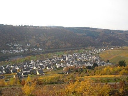
The side trail "Leiermannspfad" leads from Enkirch to Starkenburg, passing old mills and offering wide views over the Moselle Valley. Hikers can also explore the world of myths and legends – the name "Leiermannspfad" goes back to the old legend of the hurdy-gurdy man from the Ahringsbach stream
Charming excursions await along the Moselle: The side trails of the Moselsteig are circular hiking routes that allow walkers to discover many more facets of the Moselle region.
General information
Directions
The starting and finishing points of the side trail “Leiermannspfad” are the romantic wine and holiday villages of Enkirch and Starkenburg.
From Enkirch, the trail leads along a footpath to the Catholic monastery church “Klause”. It continues gently above the Ahringsbach Valley until it meets the Bachweg. After about 200 metres, hikers reach the Upper Starkenburg Mill (Obere Starkenburger Gesellschaftsmühle) from 1798. An information board and a cosy seating area invite you to rest and relax. The path then returns to the Bachweg and climbs uphill to Starkenburg.
In the village, the trail passes two historic village bakeries before reaching the scenic pavilion. Here, a rest is rewarded with a magnificent view over the Moselle Valley and far into the Eifel region. The path continues through the village and across the Kirster Höhe. Enjoy the ever-changing panoramas of the Moselle Valley, the Mont Royal plateau, the Enkirch vineyards “Zeppwingert” and “Herrenberg”, and the wine lovers’ destination of Enkirch. Narrow footpaths and romantic trails lead the Leiermannspfad back to its starting point in the village.
In Starkenburg, the Leiermannspfad can also be accessed where the Bachweg meets Schlossstraße. From there, you can either follow the trail via the scenic pavilion and Kirster Höhe or take the direct route along the Bachweg into the Ahringsbach Valley and back to Enkirch.
Safety Guidelines
The return route partly leads over slate sections, which can be slippery when wet. During the winter months, the trail may be difficult to walk due to rain and moisture.
Equipment
Sturdy footwear
Tip
Plan a short detour to the Lower Starkenburg Mill. It’s a lovely spot to take a break and recharge before the climb.
Getting there
By car via the federal road B53, L192 or L193 to Enkirch on the Moselle
Parking
Parking at the Moselle car park Enkirch - free of charge. Approx. 150m to the starting point
Public transit
By train (Easter to October): take the Moselle wine train to the Kövenig stop, then take the ferry to Enkirch - you can find out the current ferry times at the following link: www.enkirch.de/gemeinde-enkirch/ citizen info / passenger ferry / To the starting point about 150m from the ferry.
Literature
Moselsteig Seitensprünge Band 2 - Die schönsten Rundwege zwischen Bernkastel-Kues und Koblenz
ISBN-13:
9783942779609
Maps
Panorama-Wanderkarte Enkirch/Mosel
top. Wanderkarte Moselregion Traben-Trarbach Kröv ISBN
978-3-944620-24-4
Additional Information
Tourist Information Enkirch
Brunnenplatz 2
56850 Enkirch
Phone: +49 6541 4140
www.enkirch.de
Pavings
- Asphalt Coating (5%)
- Path (25%)
- Street (4%)
- Hiking Trail (65%)
- Crushed Rock (1%)
Weather

This tour is presented by: Moselregion Traben-Trarbach Kröv, Author: Wiebke Pfitzmann


